


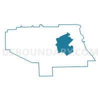
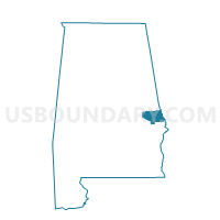
Old Salem School, Lee County, Alabama
About
Outline

Summary
| Unique Area Identifier | 522281 |
| Name | Old Salem School |
| County | Lee County |
| State | Alabama |
| Area (square miles) | 50.34 |
| Land Area (square miles) | 50.31 |
| Water Area (square miles) | 0.03 |
| % of Land Area | 99.95 |
| % of Water Area | 0.05 |
| Latitude of the Internal Point | 32.61903810 |
| Longtitude of the Internal Point | -85.23538410 |
Maps

Graphs
Select a template below for downloading or customizing gragh for Old Salem School, Lee County, Alabama


Neighbors
Neighoring Voting District (by Name) Neighboring Voting District on the Map
- Lee County Snacks Voting District, Lee County, AL
- Lee County Vol FD Voting District, Lee County, AL
- Opelika B Voting District, Lee County, AL
- Pine Grove United Meth Church Voting District, Lee County, AL
- Smiths High School, Lee County, AL
- Smiths Station Sr. Center Voting District, Lee County, AL
Top 10 Neighboring County Subdivision (by Population) Neighboring County Subdivision on the Map
- Auburn-Opelika CCD, Lee County, AL (80,779)
- Smiths Station CCD, Lee County, AL (35,058)
- Beauregard-Marvyn CCD, Lee County, AL (10,469)
- Beulah CCD, Lee County, AL (6,705)
Top 10 Neighboring Unified School District (by Population) Neighboring Unified School District on the Map
Top 10 Neighboring State Legislative District Lower Chamber (by Population) Neighboring State Legislative District Lower Chamber on the Map
Top 10 Neighboring State Legislative District Upper Chamber (by Population) Neighboring State Legislative District Upper Chamber on the Map
Top 10 Neighboring 111th Congressional District (by Population) Neighboring 111th Congressional District on the Map
Top 10 Neighboring Census Tract (by Population) Neighboring Census Tract on the Map
- Census Tract 417, Lee County, AL (8,528)
- Census Tract 419, Lee County, AL (7,623)
- Census Tract 421.02, Lee County, AL (6,826)
- Census Tract 418, Lee County, AL (6,705)